

Key takeaway
- Compare Esri, Motorola, Axon, Mark43, Hexagon, Peregrine and ElixirData on incident analytics, emergency management and crime data, plus when not to buy.
The best public safety analytics platform is the one that fits the job you need done: mapping and spatial analysis, a live command view, records and case analytics, a data fusion layer, or governance over the AI that now sits on top of all three. No single product covers incident analytics, emergency management and crime data analysis equally well. Esri, Motorola Solutions, Axon, Mark43, Hexagon, Peregrine and ElixirData each cover a different slice, so shortlist by use case first and vendor second.
Public safety buyers carry duties that ordinary analytics buyers do not. Law enforcement data is bound by the FBI CJIS Security Policy, and emergency management programmes that want federal preparedness grants must adopt the National Incident Management System (NIMS). Disclosure: XenonStack sells one of the options below (ElixirData). We compare every option on the same stated criteria, and vendor claims are worded "according to its site".
What rules shape a public safety analytics purchase?
Two official frameworks shape most shortlists. Neither names a product, but both change what you can buy.
- FBI CJIS Security Policy. It sets the security baseline for criminal justice information, and it applies to agencies and to the vendors and cloud providers that handle that data. The FBI's law enforcement site hosts version 6.0, dated 27 December 2024 by its file name. Confirm the current version and your state's CJIS Systems Agency requirements before signing, because states can add their own rules.
- NIMS. According to FEMA, NIMS gives all levels of government, nongovernmental organisations and the private sector "shared vocabulary, systems and processes" for managing incidents, and local, state, territorial and tribal jurisdictions "are required to adopt NIMS in order to receive federal Preparedness grants". An emergency management tool should speak that vocabulary, not force your teams to translate.
The practical reading: ask every vendor for its CJIS position in writing, ask how its data model maps to NIMS resource and incident terms, and ask who can see what. None of the vendor pages we read for this guide stated a CJIS or NIMS position in the passages we could access, so treat those as questions for the sales call, not assumptions.
Which criteria should you compare on?
We used six criteria that public sector buyers can test in a proof of concept.
- Primary job: mapping, command view, records and cases, data fusion, or decision governance.
- Incident analytics: can it show patterns, hotspots and timelines across incidents?
- Emergency management fit: does it support situational awareness and multi-agency response?
- Crime data analysis: link analysis, pattern detection and case support for analysts.
- Data integration: how it handles CAD, records, video and other sources you already own.
- Accountability for AI: can you show why an automated output was produced and who approved action on it?
What are the best public safety analytics platforms?
The order is not a ranking. Claims come from each vendor's own pages, read on 13 November 2026. Where a page did not load or did not say something, we say so.
1. Esri ArcGIS: spatial analysis and operational dashboards
According to Esri's law enforcement page, maps and spatial analysis show police "where and when crime is occurring", and dashboards combine live data feeds and personnel locations into "a complete operational picture". It names ArcGIS AllSource for "link analysis, threat assessments, imagery exploitation, and more for criminal investigations", and ArcGIS Hub for engaging residents. Its public safety page also links to emergency management resources and a Disaster Response Program. A good fit when location is the core of your analysis. It is a mapping and analysis layer, so you will still need dispatch and records systems underneath it.
2. Motorola Solutions CommandCentral Aware: a live command view
According to its product page, CommandCentral Aware integrates "voice, data and video into a single, real-time intelligence position", pulling camera feeds, incident details, resource locations and alerts into one map or activity view, with rules that automate routine steps. A good fit for a real-time crime centre or a large command room that wants one operational picture. The page describes situational awareness more than long-run crime analysis, so test the analyst workflow separately.
3. Axon Records: a records system with connected intelligence
According to its product page, Axon Records is "the next generation records management system" that "unifies data, evidence, and AI-driven reporting in one secure, cloud-native platform". Axon calls it a "CAD-agnostic RMS", and says detectives "get real-time visibility into people, vehicles, and incidents linked across cases". The page does not use the word analytics and does not mention CJIS, so ask for both in writing. A good fit when the records system is the centre of your case and evidence workflow.
4. Mark43: dispatch, records and analytics in one cloud platform
According to Mark43's site, its dispatch product lets agencies "seamlessly assign and manage units with real-time visibility", its records product helps "connect evidence, cut duplication, and close cases faster", and Mark43 Insights is meant to "unlock the power of agency data to drive decisions". It describes a cloud service with no software or hardware to manage. The page does not mention crime analysis or CJIS by name. A good fit for a department that wants CAD, RMS and reporting from one vendor.
5. Hexagon HxGN OnCall Analytics: analytics built on dispatch data
According to Hexagon's blog post, published in July 2019, HxGN OnCall Analytics is "a suite of public safety data visualization and analytics products" with interactive reports and dashboards, "pin and hotspot mapping", "dynamic clustering" and playback of event sequences, backed by a data warehouse that supports third-party access. The post is several years old, so confirm the current feature set on Hexagon's site. Hexagon's own product pages did not load for us. A good fit for emergency communications centres that already run Hexagon dispatch.
6. Peregrine: fusing fragmented agency data
According to Peregrine's site, its full-stack platform "transforms disconnected data into complete operational context", with data ingestion and enrichment, forward deployed engineers who work "directly with your team on site", and "granular access controls". The page names no security certifications, so request them. A good fit when your core problem is many disconnected systems and you want one view across them.
7. ElixirData Context OS: governing the decisions AI makes on public safety data
XenonStack sells this option. According to the Context OS page, it sits between enterprise data and AI agents, builds a context graph of entities, rules and provenance, checks policy before an agent acts, and records each decision as a trace of the context used, the policies checked, the authority verified and the outcome. Low-risk actions can be approved automatically, while high-risk actions need human oversight. The page also lists deployment, cost and traceability figures, which are the vendor's own claims and which we have not verified. ElixirData is not a CAD, records or mapping product. It is a governance layer you add when AI starts recommending or taking actions on incident and crime data. See the Audit Agent page: it states it can only produce complete decision lineage for decisions made through Context OS.
How do the seven options compare?
| Platform | Primary job | Incident analytics | Emergency management fit | Crime data analysis | Confirm before buying |
|---|---|---|---|---|---|
| Esri ArcGIS | Mapping and spatial analysis | Dashboards, hotspots by location | Situational awareness, disaster response resources | AllSource link analysis | Dispatch and records integration |
| Motorola CommandCentral Aware | Live command view | Real-time activity view | Voice, data and video in one position | Search on suspicious activity | Analyst workflow depth, CJIS position |
| Axon Records | Records and evidence | Linked people, vehicles, incidents | Not stated on page | Case linking for detectives | Analytics scope, CJIS position |
| Mark43 | CAD, RMS, reporting | Insights product | Unit assignment visibility | Not stated on page | Crime analysis features, CJIS position |
| Hexagon HxGN OnCall Analytics | Analytics on dispatch data | Dashboards, clustering, playback | Event and incident playback | Pattern views | Current feature set, certifications |
| Peregrine | Data fusion | Operational context across sources | Not stated on page | Not stated on page | Certifications, integration effort |
| ElixirData Context OS | AI decision governance | Not an analytics engine | Policy gates and escalation | Not a crime analysis tool | Fit with your data sources |
Which platform should you pick for your use case?
| If your main need is | Start with | Why |
|---|---|---|
| Hotspot and pattern mapping for analysts | Esri, Hexagon | Both describe spatial analysis and hotspot mapping on their own pages |
| A real-time crime centre or command room | Motorola, Esri, Peregrine | Each describes a combined live view across sources |
| Case management with analytics | Axon, Mark43 | Both pair records with linked or insight views |
| One view over many disconnected systems | Peregrine | Its page centres on data ingestion and enrichment |
| Proving that AI recommendations were approved and policy checked | ElixirData, alongside any of the above | It governs decisions rather than replacing the analytics tool |
What does an AI-ready public safety stack look like?
Most agencies will not buy one product. They will run a mapping layer, a records and dispatch system, and a fusion or command view, then add AI features such as summarisation, alerting and automated recommendations. That last step is where risk grows. An analyst can explain a map. It is harder to explain why a model flagged a person or an area, who reviewed it and which policy applied.
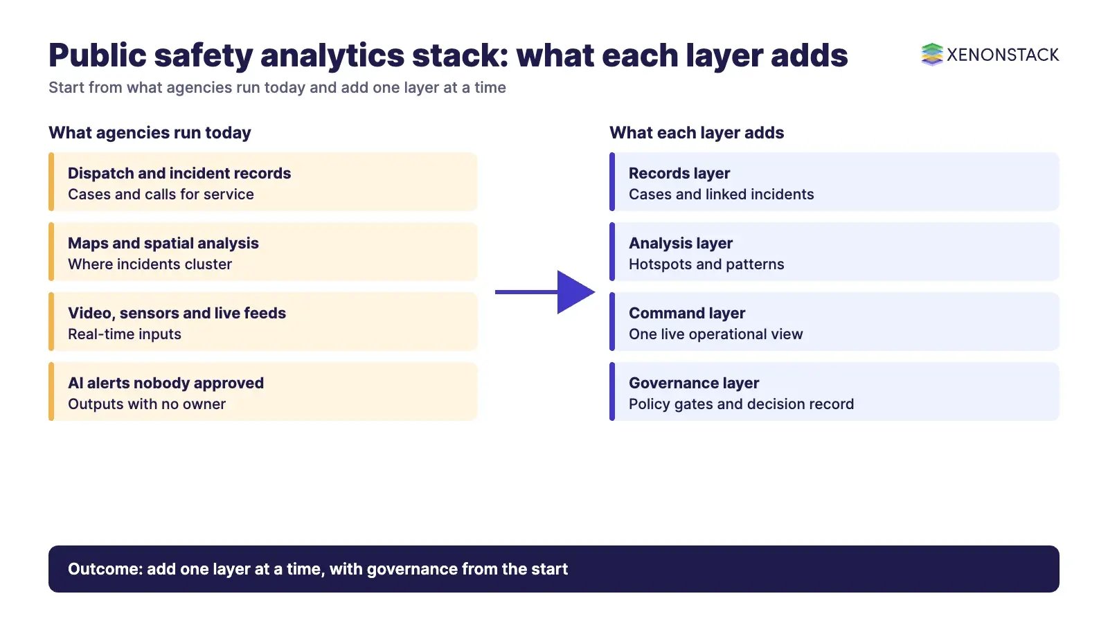
Plan for four layers. First, the source systems: dispatch, records, video and sensors. Second, the analytics layer your analysts use daily. Third, the governance layer that decides what an AI agent may do on its own and when a person must approve. Fourth, the evidence layer that stores a record of each decision. XenonStack's articles on agentic analytics, bounded autonomy and decision memory cover the design in more depth. For how agent limits are enforced, read AI agent governance, and for compliance mapping see agentic AI governance and compliance. Teams that need to watch agent behaviour in production can start with agentic observability, and the groundwork for all of it is sound data governance.
How should you run the evaluation?
- Pick three real scenarios. For example, a multi-agency flood response, a burglary series across districts, and a major event with road closures.
- Load your own data. Use sanitised extracts from your dispatch and records systems, not the vendor's demo data.
- Ask for the CJIS and access model in writing. Who can see which records, and how is every access logged?
- Test the hand-offs. Check how the tool receives data from CAD and records, and how it sends findings back.
- Ask the audit question. Pick a recent automated flag and ask the vendor to show who approved action on it and why.
- Check support terms. Confirm response times during a live incident, not just in office hours.
When should you not buy a new public safety analytics platform?
- Your data is not shared yet. If dispatch and records cannot be exported in a usable form, fix that first. A new dashboard on poor data produces poor answers faster.
- Your current system already covers the need. If your CAD or records vendor ships analytics you have not switched on, test that before adding another vendor.
- You have no analyst capacity. Link analysis and pattern tools need people who use them. Without them, the licence sits unused.
- You want AI to decide on people. Automated outputs that affect individuals need human review and a clear audit record. If you cannot provide that, do not turn the feature on.
- You are buying ElixirData for mapping or dispatch. It does neither. It fits only when you need governance and evidence around AI decisions.
Where can you test the governance layer?
If AI is entering your command room or analyst workflow, the governance question comes before the vendor question. See Context OS in action with the Context OS demo, or book a working session through the Context Workshop to map your own incident decisions, policies and approval paths.
Frequently asked questions
What is a public safety analytics platform?
It is software that turns incident, dispatch, records, video and sensor data into maps, dashboards and findings for police, fire, emergency medical services and emergency management teams. Some products focus on mapping, some on records and cases, some on live command views, and some on data fusion.
Which platform is best for crime data analysis?
It depends on the work. For spatial patterns, Esri and Hexagon describe hotspot and mapping features on their own pages. For case linking, Axon describes linked people, vehicles and incidents. Test each with your own data, since page descriptions do not show analyst workflow depth.
What does CJIS mean for analytics vendors?
The FBI CJIS Security Policy sets security requirements for criminal justice information and applies to the agencies and vendors that handle it. Ask each vendor for its CJIS position in writing and confirm the current policy version and your state's added rules.
Do emergency management teams need to follow NIMS?
According to FEMA, local, state, territorial and tribal jurisdictions are required to adopt NIMS to receive federal preparedness grants. Choose tools that fit its shared vocabulary for incidents and resources.
Is ElixirData a replacement for CAD or records software?
No. XenonStack sells ElixirData as a governance layer for AI decisions. It does not replace dispatch, records or mapping tools, and its audit agent can only produce complete lineage for decisions made through Context OS.
How should agencies govern AI in public safety?
Set clear limits on what an AI agent may do alone, require human approval for high-impact actions, and keep a record of the data, policy and approver behind each decision. Review those records regularly, not only after an incident.
Ready to put AI agents to work? Explore ElixirClaw, the agentic OS platform to build, orchestrate and govern AI agents.
Explore the XenonStack platform family: ElixirData · ElixirClaw · ElixirHub · NexaStack · MetaSecure · Neural AI · AgentGRC · AgentSRE · AgentAnalyst · AgentInstruct · AgentRAI · AgentScrum · AgentSearch · AgentForce · AI Aviator · SAIF Aviator · CohortIQ · XenonStack AI · XenonStack UAE


