Key takeaway
- Learn how Presto (Trino) and Apache Hive handle geospatial analytics: spatial types, architecture, file formats, tuning and when to use each engine.
Geospatial analytics with Presto and Hive means running SQL over location data, such as points, lines and polygons, that sits in a data lake or warehouse, so that questions about where things are can be answered at scale. Location data comes from GPS, geographic information systems (GIS) and remote sensing, and it grows with every phone, vehicle and satellite pass.
This guide is for data engineers and analytics leads who already run, or are choosing between, Hive and a Presto-family engine. It covers how each engine is built, how spatial data is modelled and queried, how to tune the work, and how AI agents change who writes the queries. See also our guides to geospatial visualization tools and techniques and intelligent decisioning systems.
What is geospatial analytics and why does it matter?
Geospatial analytics is the practice of collecting, storing, manipulating and presenting data that is tied to a place on Earth. GIS handles collection, storage, analysis and presentation of spatial data, GPS supplies positions, and remote sensing, such as satellite imagery, supplies observations of the surface.
Spatial questions are joins and filters over very large tables, so the query engine matters. Results are usually passed on to data visualization tools, and the same pipelines feed recommender systems, stream analytics and sector work such as data analytics in the insurance industry.
How do Presto and Hive differ?
The two are often named together, but they do different jobs. Apache Hive describes itself on its project site as a "distributed, fault-tolerant data warehouse system that enables analytics at a massive scale", built on Apache Hadoop with support for S3, Azure Data Lake and Google Cloud Storage. The PrestoDB documentation describes Presto as "a distributed SQL query engine designed to query large data sets" spread over heterogeneous data sources.
| Question | Apache Hive | Presto family (Trino, PrestoDB) |
|---|---|---|
| What is it? | A data warehouse system with a SQL interface and a metastore for table and partition metadata | A distributed SQL query engine that queries data where it already lives |
| Interactive queries | Offered through LLAP, which the Hive site describes as interactive and sub-second SQL | The main design goal of the engine |
| Spatial support | Added through the Esri Spatial Framework for Hadoop (UDFs and SerDes) | Built in: geometry types and ST_ functions in Trino |
| How they meet | The Hive site lists Presto among the tools Hive integrates with | Connectors let it read tables that Hive manages |
How does a Presto-family engine work?
The architecture terms below come from the Trino concepts page; check the documentation of the engine you actually run for differences. A coordinator is "responsible for parsing statements, planning queries, and managing Trino worker nodes". A worker is "responsible for executing tasks and processing data". A connector "adapts Trino to a data source such as a data lake", and a catalog is a collection of configuration properties used to access a specific data source.
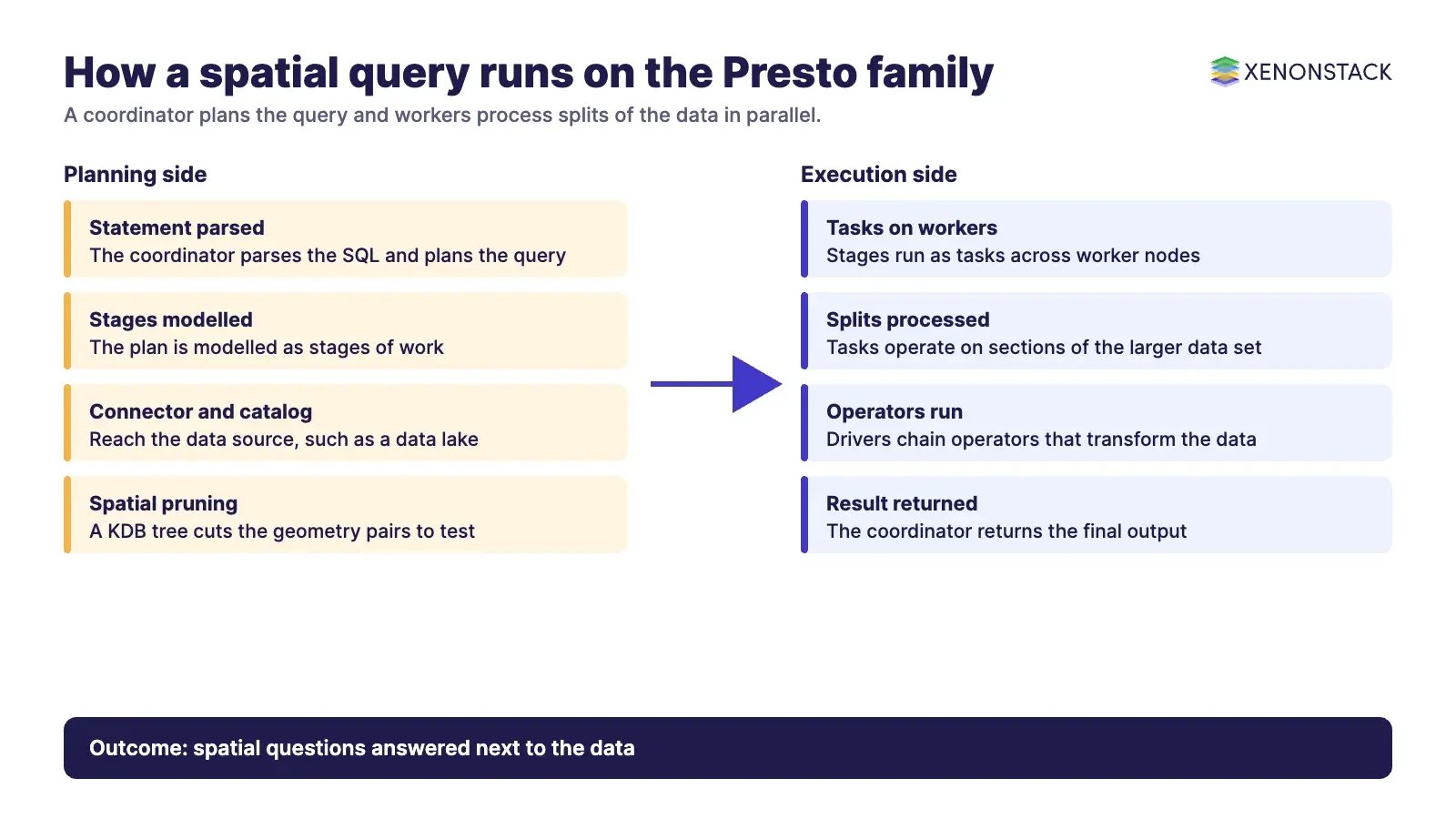
When a statement is parsed it becomes a query with a distributed plan. The plan is modelled as stages, stages run as tasks, and tasks "operate on splits, which are sections of a larger data set". An operator "consumes, transforms and produces data".
What does Hive look like inside?
Hive offers a SQL interface over files in distributed storage. Clients connect through open APIs such as JDBC and ODBC, a driver compiles and runs each query, the Hive Metastore serves metadata for tables and partitions, and data sits in storage such as HDFS or an object store. Confirm which execution engine your Hive version uses before tuning, and rely on the current Hive documentation, not on older write-ups.
How is geospatial data modelled and queried?
Locations are usually modelled as geometries: points, lines and polygons, written as Well-Known Text (WKT). The Trino geospatial functions page says its functions support WKT, EWKT, WKB and EWKB, with KML and GeoJSON also supported. It distinguishes planar Geometry values from SphericalGeography values, where distances are in metres. Constructors include ST_Point(), ST_Polygon() and ST_GeometryFromText(), relationship tests include ST_Contains(), ST_Intersects() and ST_Within(), and measurements include ST_Distance() and ST_Area().
A typical question, such as which pickups fall inside a zone, is a join on ST_Contains(zone_geometry, ST_Point(longitude, latitude)). For large joins the same page describes functions that "build and apply a KDB tree for spatial joins", which prune work before the exact test. Overlay operations fail on invalid input by default, so check geometries with ST_IsValid() first.
Hive has no spatial types of its own. The Esri Spatial Framework for Hadoop adds them for Hive, and its page lists Hive 0.11 and above as a requirement and the Esri Geometry API as a dependency. Its listed copyright runs from 2013 to 2020 and the page shows no recent release notes, so check how actively it is maintained before you build on it.
How do you tune geospatial queries?
Most gains come from reading less data. The Hive ORC documentation describes ORC as "a highly efficient way to store Hive data", with lightweight indexes holding minimum and maximum values that let readers skip row groups that fail a filter.
| Technique | Applies to | What it does |
|---|---|---|
| ORC or other columnar format | Hive and Presto family | Stores columns together and lets readers skip row groups that cannot match |
| Partitioning | Hive tables read by either engine | Reads only the partitions a query needs, such as one region or day |
| Sorting on filter columns | Hive ORC tables | The ORC page notes that sorting on secondary keys lets readers skip large sets of rows |
| Spatial pruning | Trino | Uses a KDB tree for spatial joins so most geometry pairs are never tested |
Where can you run them?
Both engines are available as managed services on the major clouds, for example Amazon EMR for Hive and Presto-family clusters, Amazon Athena for serverless queries and Google Cloud Dataproc for Hadoop-based clusters. Names and versions change, so confirm them in each provider's documentation. See also our guide to AWS data lake analytics, and for the wider picture see trends in big data analytics.
How do AI agents change geospatial analytics?
Agents turn spatial questions into queries. A planning agent may write ST_Contains joins, read the result and decide what to do next, so every table it can reach becomes part of a decision. That needs clear column definitions, access rules for precise locations, and a record of which query led to which action. XenonStack's Context OS, ElixirData, is the product page to read for governed data context behind agents.
What should you do first?
- List the five spatial questions your teams ask most and the tables they touch.
- Record where each table lives and which engine reads it today.
- Store geometry as WKT or a native geometry type, with a documented coordinate system.
- Convert hot tables to ORC and partition them by region or date.
- Test one spatial join on both engines with the same data.
- Decide who, human or agent, may run spatial queries on precise location data.
To map one decision your agents make from location data, and the data and policy it depends on, book a Context Workshop. See what happens in the workshop.
Frequently asked questions
Can Hive run geospatial queries?
Not on its own. Hive needs an add-on such as the Esri Spatial Framework for Hadoop, which provides spatial types and functions, and you should check that project's maintenance status before relying on it.
Does Presto support geospatial analytics?
The Trino documentation lists geometry types, WKT input and output, ST_ functions and spatial join support. Other Presto-family engines may differ, so check the documentation for your version.
Which should I choose, Presto or Hive?
They solve different problems. Hive provides a warehouse and metadata layer, while a Presto-family engine provides fast distributed queries across data sources, and many teams use both together.
What file format is best for spatial tables?
A columnar format such as ORC is a sound default because readers can skip row groups that fail a filter. Store the geometry as WKT or a native geometry type and document the coordinate system.
How do AI agents use spatial data?
Agents write and run spatial queries, then act on the results. Teams therefore need clear column definitions, access limits for precise locations and a record of each query behind an action.
Follow XenonStack on LinkedIn: XenonStack on LinkedIn for new guides on agentic AI, data and platform engineering.
Ready to put AI agents to work? Explore ElixirClaw, the agentic OS platform to build, orchestrate and govern AI agents.
Explore the XenonStack platform family: ElixirData · ElixirClaw · ElixirHub · NexaStack · MetaSecure · Neural AI · AgentGRC · AgentSRE · AgentAnalyst · AgentInstruct · AgentRAI · AgentScrum · AgentSearch · AgentForce · AI Aviator · SAIF Aviator · CohortIQ · XenonStack AI · XenonStack UAE